
Japan’s hazard maps: what your broker must show you, and what they don’t
Since 2020, a Japanese agent has been legally required to show you where a property sits on the flood hazard map. Landslide and tsunami are covered only as to whether a formal alert zone applies, and liquefaction and earthquake carry no duty at all. Knowing which is which is on you.
In short
- Since August 2020, the flood hazard map position of a property must be explained before you sign. That covers river flooding, inland water and storm surge.
- Landslide and tsunami appear only as to whether the property lies in a designated alert zone, not where it sits on a hazard map. Liquefaction and earthquake shaking are outside the explanation entirely.
- Sitting outside a flood zone is not a statement that the property is safe. It means no depth was modelled there, on that map, in that year.
What the law actually requires
Before you sign anything in Japan, a licensed specialist reads you a document called the important matters explanation (jūyō jikō setsumei, 重要事項説明). It is the single most important half hour of a Japanese property purchase, and it is delivered in Japanese, at speed, by someone employed by the firm handling the sale.
On 28 August 2020 the ministry added a new item to that document. Agents must now show you where the property sits on the flood hazard map (suigai hazādo mappu, 水害ハザードマップ) published by the municipality. The rule applies to purchases and to rentals alike. It was introduced after a run of severe rainfall disasters in which the areas that flooded turned out to match the areas the maps had predicted.
Two things about this duty are easy to miss, and both matter to you.
First, the duty covers water only. The maps in scope are those produced under the flood control legislation: river flooding, rainwater and inland flooding, and storm surge. Nothing else.
Second, the duty is to show you where the property is on the map. It is not a duty to assess the risk, to interpret the colour band, or to tell you what it means for the building you are about to buy. If the municipality has not published a map at all, the agent states that no map exists and the obligation is satisfied.
The law makes someone show you where the property sits. It does not make anyone tell you what that means.
What the other hazards get
Landslide and tsunami are handled differently from flooding. The explanation must state whether the property lies in a formally designated landslide alert zone or tsunami alert zone, but nobody is required to show you where it sits on the landslide or tsunami hazard map, and risk outside a formal designation is not mentioned at all. Liquefaction and earthquake ground motion carry no duty to explain.
So a property can sit outside every flood band and every designated zone and still be on soil with a known liquefaction history, or within reach of a modelled tsunami. Of the designations that are disclosed, the landslide pair is the one most worth understanding before you buy a house on or below a slope.
Yellow zone and red zone are not the same thing
Japan designates two levels of landslide zone, and English-language listings almost never distinguish between them.
| Designation | What it does |
|---|---|
| Alert zone 土砂災害警戒区域 |
Often called the yellow zone. It triggers evacuation planning and hazard information duties for the municipality, and whether the property lies in it must be stated in the pre-contract explanation. It does not restrict what you may build. |
| Special alert zone 土砂災害特別警戒区域 |
Often called the red zone. Residential subdivision and certain development requires prefectural permission. Buildings with habitable rooms are subject to structural requirements. Relocation may be formally advised. An agent cannot advertise or contract on affected land before the permission is granted, and the permission itself must be explained to you. |
For anyone looking at a rural house or an akiya on sloping ground, the red zone designation is not a background detail. It can decide whether the building can be replaced at all, and what it would cost to build something that satisfies the structural requirement. That question needs answering before you make an offer, not after.
Reading the colours
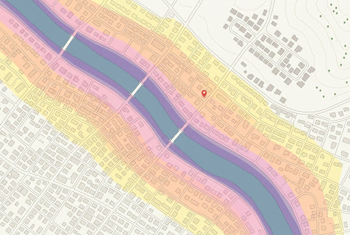
Flood maps use graded colour for predicted depth, with the bands set out in the legend in metres. Pale is shallow, deep is deep.
The scale measures depth, not probability. A plot in a three metre band is not three times more likely to flood than one in a one metre band. Both are describing the same modelled event, and the event being modelled is printed in the legend.
That last point is where comparison quietly breaks down. Municipalities publish against their own assumed scenarios, and maps are revised on their own schedules. Two neighbouring towns can produce maps that look alike and are not measuring the same thing. If you are weighing up properties in different municipalities, the maps are not directly comparable until you have read both legends.
What a blank area means
If the property does not fall inside any coloured band, the honest reading is narrow. No depth has been recorded at that location, for that scenario, on that map, as of its reference year.
Smaller municipalities may not have modelled every scenario. Some maps are a decade old. Some cover the main river and not the smaller watercourse behind the house. None of that appears on the map itself, and none of it is something the disclosure duty asks anyone to mention.
The ministry's own guidance is explicit on this point. Agents are told to take care that buyers do not come away believing that being outside a designated area means there is no flood risk. That instruction exists because the misreading is common.
What this does not mean
No recorded flood depth at a coordinate means nobody has mapped a risk there. It does not mean the property does not flood. We will not write it as though it does, and neither should anyone else.
Where a dataset returns nothing, we say the dataset returned nothing, and we tell you which municipal office holds the underlying assessment.
Where to look for yourself
The Geospatial Information Authority runs a national hazard map portal that gathers municipal maps in one place. It has two modes: an overlay view that stacks national hazard layers on a single map, and a directory that sends you to the individual municipality's own published maps. Both are in Japanese, and the second is usually where the detail lives.
The municipal website is the authoritative source, and the office that produced the map is the place to take a question the map cannot answer. If you are working from a listing rather than from the municipality, you may never see which scenario was modelled. That is one of several things worth verifying yourself before you commit to a property.
Ground conditions are worth reading alongside the hazard designations rather than after them. Elevation relative to the surrounding land, the slope of the plot, and whether the ground was cut or filled all shape how water behaves before any map is consulted. We go into that separately in why slope and fill matter more than the photographs suggest.
Hazard is one part of a wider picture. If you are earlier in the process, start with the full guide to buying property in Japan as a foreign buyer.
Check a property
Enter an address and see the hazard designations recorded at that exact coordinate, with the source and reference year for each, alongside terrain, zoning and land value. Your first property is free.
Research a propertySources
Ministry of Land, Infrastructure, Transport and Tourism — amendment to the enforcement regulations of the Real Estate Brokerage Act adding flood hazard map disclosure, in force 28 August 2020, and the accompanying guidance and Q&A. Real Estate Brokerage Act enforcement regulations — disclosure of whether a property lies in a sediment disaster alert zone or a tsunami disaster alert zone. Sediment Disaster Prevention Act — alert zone and special alert zone designations, development permission and structural requirements. Geospatial Information Authority of Japan — national hazard map portal. Municipal hazard maps published by individual local governments; reference years vary by municipality and are shown per dataset in our reports.